Wednesday, January 25, 2012

Dorm room and icebreaker vessel

7:40am Thursday, 1/26/2012
15°F 


My posts may less interesting and less frequent now as my last three weeks down here may not include another adventure out in the field. Like today, I've decided to share photos of my dorm room and the ice breaker vessel circling around in the sea ice in front of McMurdo.


Dorm Room


My dorm room has two beds and has mostly only been occupied by me. I have heard that rooms of the same size can have a set of bunk beds so that the maximum occupancy can be three people, but thankfully my room isn't like that. With the exception of my first week here and two nights last week, I have had my room all to myself and it's been quite nice. 


The furniture isn't all that exciting, but it serves its purpose. My mattress is really comfortable and I enjoy being next to the window. I still haven't decided if I like sleeping with it open wearing a sleeping mask or sleeping with it closed and waking up to darkness. It is surreal that the sun never sets. I am not sure how one gets used to that.


Right across from my room is the women's restroom for my floor and down the hall is the laundry room. I imagine this is what living in the dorms at a college is like and I have to admit I am not sorry I missed out on years of living like this.


My bed for the last 6 weeks

My closet
Where my shoes live. My toe shoes are on
my feet, which is why they aren't in the lineup
My bag of warm clothes
goodies!


Icebreaker


The icebreaker vessel has arrived and it's clearing the way between the Ross Sea and McMurdo through the Ross Ice Shelf for the cargo vessel that arrives in mid February. The cargo vessel will take away the summer's waste and bring supplies for winter and next summer. It's very strange to see open water out in front of McMurdo and even stranger to see a ship moving around in and disturbing the sea ice.


Its progress- all the open water is new as of its arrival

The icebreaker and Mt. Discovery


Breaking a pathway in the sea ice

Saturday, January 21, 2012

Two short videos of Taylor Valley

Taylor Valley from Lake Hoare field camp:
http://www.facebook.com/video/video.php?v=3036350278112


Flying into Taylor Valley over the Asgard Range from Wright Valley:
http://www.facebook.com/video/video.php?v=3036542482917

Hiking on Lake Hoare with Amy

12:05am Sunday, 1/22/2012
25°F


After getting back to Lake Hoare field camp after speed sampling the Onyx River on January 17th, Amy and I did some work before setting out for a small adventure on the lake. She went to one of the labs (the instrument lab) to do paperwork involved in tracking radioactive material and I went to the chemistry lab to filter and prep my samples we'd just collected.


Once we got a couple hours of indoors work under our belts, we ventured out onto the lake to retrieve three instruments that Amy and the Limno Team had left in the lake a couple of months ago on behalf of another researcher. These instruments measured temperature and pressure. The researcher who wanted them put in was curious about large scale, temperature driven, lateral movement of water under the lake ice (I think). 


The ice on the lake had melted out a lot since we'd been out a couple of weeks ago for Lightening Round. There were lots of little caves with icicles in them and the landscape was very rough.


Little ice cave in a bank of ice about 3 feet high on
Lake Hoare
Icicles in the little ice cave


We found the first instrument without much trouble because there was still some cargo out in the center of the lake near where the Limno Team had drilled their hole in the ice and the ablated ice from under the polar haven was still very visible. The second instrument was along the northern shore of the lake about a third of the way down the lake from Lake Hoare camp. Amy had us wear life vests because this late in the summer season it's possible that the moat ice isn't as thick as it seems and/or melt ponds on the permanent lake ice are thinly covered and rather deep.


Looking east back toward camp and
Canada Glacier
Looking west, up valley, toward
Seuss Glacier


We walked down valley a ways across the lake ice, which was rather rugged terrain! We came across a large  melt pond that had refrozen. It was a spectacular shade of light, bright turquoise and had a ridge of ice around it, which was surrounded by a depression or small crevasse that had algal mats frozen into it.

Algal mats, little ridge line, and melt pond

Close-up of algal mats

Amy checking out the re-frozen melt pond

We crossed the refrozen melt pond without incident (and with confidence because we had our life vests on) and continued across the lake in search of the other instrument we were tasked to retrieve. Eventually we decided to trek along the moat and thanks to a well placed flag and good luck we found the instrument we were looking for. Our walk back to camp was mostly along the frozen moat and in the shade of the northern wall of the valley. It was a lovely little hike without any traumatic events, getting wet, or having to search long and hard for the instruments we were retrieving.

Looking up valley (west) along the frozen moat toward
Seuss Glacier in the shade of the norther valley wall

Amy on the moat in her life vest (looking east toward Lake
Haore camp and Canada Glacier)

Amy and me in our life vests!

Friday, January 20, 2012

Onyx River Speed Sampling (and a bit of regional geography)


4:50pm Friday, 1/20/2012
27°F


I decided that I should preface this post, albeit belated, with a short discussion of where I actually am. I am based out of McMurdo Station, which is located on an island (Ross Island) in the Ross Sea. Ross Island hosts several cinder cones and the active stratovolcano, Mt. Erebus. At this latitude, Ross Sea is ice covered for much of the year and the ice-covered sea is dubbed the Ross Ice Shelf. 


Map of Antarctica, with the red square roughly outlining the areas I have visited


The Dry Valleys are located on the main continent of Antarctica and are due west of Ross Island. There are several valleys in this area and I have had the privilege of visiting four of them: Taylor, Miers, Garwood, and Wright. 


The locations (I think, the text is pretty blurry) of the four Dry Valleys I've set
 foot in so far relative to Ross Island
1- Wright Valley
2- Taylor Valley
3- Garwood Valley
4- Miers Valley


Another map of the Dry Valleys, with the four valleys I've visited highlighted

Wright Valley


Amy (of the Limno Team), Micheal Davis (who works in the lab facility in McMurdo where my group has a few rooms), and I flew to Wright Valley on January 17th for a day trip to sample the Onyx River. This was my first “solo” field excursion in Antarctica, meaning I was in charge of this sampling work! I was tasked with collecting eight sets of water samples along the extent of the Onyx River at coordinates that have been sampled in previous years. The Onyx River is the longest river in Antarctica. It is 25 miles long and flows from Lake Brownworth to Lake Vanda; the Onyx River is unique in that it flows away from the ocean (east to west in the maps above). 


Amy, Michael, and I were on time and well prepared for our trip to Wright Valley. We arrived at the helicopter hanger well before our scheduled 8:15am departure time. The helicopter technicians were so proud of us that they took our photo in the hanger.


Michael, Amy, and me. Of course, my eyes are shut...


We had the pleasure of flying in an A Star because we had closed support, which means the helicopter would stay with us as we did our work. The flight out to Wright Valley was beautiful. Clouds at the seaward end of the valley forced us to fly over the peaks along the south wall of Wright Valley, which make up the Asgard Range. There is a ridge line that is very wind eroded. It was beautiful!

Flying across Ross Sound to the Dry Valleys.
Not sure which valley that is...

The eastern/seaward end of Wright Valley socked in

Wind eroded ridge on the southern wall of Wright Valley

Looking at the eastern/seaward end of Wright Valley
socked in from in the valley

Sampling the Onyx River was incredibly exciting. My two assistants were very helpful. Amy measured pH (acidity) and temperature in-situ (i.e. directly in the river water) with a handheld instrument, Michael wrote down the pH and temperature values, and I collected water samples for major ion chemistry, dissolved organic carbon, total nitrogen, and the stable isotope composition of the water molecules themselves. 

Amy (left) measuring ph & water temperature and me (right) collecting water samples

We were able to collect four of the eight samples before we had to fly back to the coast of McMurdo Sound, to Marble Point, to refuel. The flight out of the valley was spectacular and then it was gloomy at and around Marble Point.

Flying over a glacier on the southern peaks along the Wright Valley on the
way to Marble Point to refuel

Getting very close to Marble Point, the white in the background to the right
is Ross Sound

The flight back to Wright Valley from Marble Point was also spectacular! We took a slightly different route over some beautiful ice falls. Amy said this trip, in its totality, was one of the most amazing and spectacular of her time in Antarctica. Michael had never been out to the Dry Valleys before. He works in what we call "Science Cargo," so it was wonderful that he was chosen as our extra helper on this trip.

Looking south from above a glacier in the Asgard Range

Michael (left) and Barry (right; the pilot!) as we flew back
to Wright Valley for the last 4 samples 

Close up of some ice falls in the
Asgard Range
More of the ice falls in the
Asgard Range


Looking upstream toward the sea in Wright Valley along the Onyx River,
there was still cloud cover near the sea 

Looking downstream in Wright Valley along the Onyx River

We collected the latter four sample sets along the Onyx River with as much ease and speed as the first four. The water was very cold, just above freezing, and the river was lines with ice along its banks at most sites. The final sampling site, which is just before the river ends in Lake Vanda, was spectacular. Lake Vanda is a beautiful shade of turquoise and just before it empties into the lake, the river runs over larger rocks than in the rest of the valley making lots of noise.

The bank of the river channel was more than a foot high and
saturated with water at the second to last sampling site so I lay
on my stomach to collect the water samples


Looking upstream from the last sampling site right next to
Lake Vanda. Look at all that water!

Michael and Amy at the last sampling site

Me at the last sampling site in front of Lake Vanda and the
end of the Onyx River

Our flight from Wright Valley to Taylor Valley, which was where Amy and I were spending the night, was, as you might guess, absolutely spectacular. Instead of oodles more photos, I would love to post a 90 second video of our helicopter ride as we passed into Taylor Valley. But, it seems I can't. I shall end this post with these three photos of our flight from Wright Valley to Taylor Valley. Since this post is so long, I shall post again about our stay at Lake Hoare and our adventure hiking around on the lake in life vests. Hopefully I can figure out how to post videos, if it's possible to do from down here...

Looking back toward Wright Valley across a high elevation glacier
valley in the Asgard Range

Looking toward Taylor Valley in the Asgard Range

Looking down Taylor Valley toward the sea. The glacier in the foreground is the
Seuss Glacier, which forms a barrier between Lake Hoare and  East Lake
Bonney. The next is the Canada Glacier and the glacier furthest in the
background, past the lake (Fryzell) beyond the Canada Glacier, is the
Commonwealth.


Wednesday, January 18, 2012

Two new valleys- Garwood and Miers

10:25pm Wednesday, 1/18/2012
23°F

Since my adviser, Berry, has been in town I have been going out in the field almost nonstop! It's been amazing the last couple weeks flying all over the Dry Valleys. During the last week, despite weather delays, I had three amazing trips to three new Dry Valleys: Garwood, Miers, and Wright. I just got back from my trip to Wright Valley this morning, but I left my camera at Lake Hoare field camp so I will have to post about that trip later. For now, I’ll share my trips to Garwood and Miers Valleys.

I am not sure whether I have said this yet, but all of the Dry Valleys start up valley with a glacier (or two), may have glaciers on the valley walls that “flow” perpendicular to the valley from the summits of the surrounding ranges into the valley, and terminate at the “ocean,” which is the Ross Sound/Sea that is covered in ice. Each of the Dry Valleys has some kind of water body. Taylor Valley, the only valley I’d visited up until Garwood, has several lakes, numerous streams that flow into the lakes, and ponds. Garwood Valley has a stream and numerous small ponds. Miers Valley has two streams and one lake. Finally, Wright Valley has one river (the longest river in Antarctica at 18 miles!). Again, I’ll discuss Wright Valley in my next post.

Garwood Valley

Berry and I flew to Garwood Valley on January 13th for a day trip with another professor that works in our group (http://www.mcmlter.org/) named Andrew Fountain whose focus is glaciers and works at Portland State. We met up with Joseph Levey out in Garwood Valley. He’s a post doctoral researcher at Oregon State and used to be a student of Andrew’s. Garwood Valley doesn’t have any snow on the valley floor, but Garwood Stream flows through the valley from the glacier to the ocean.

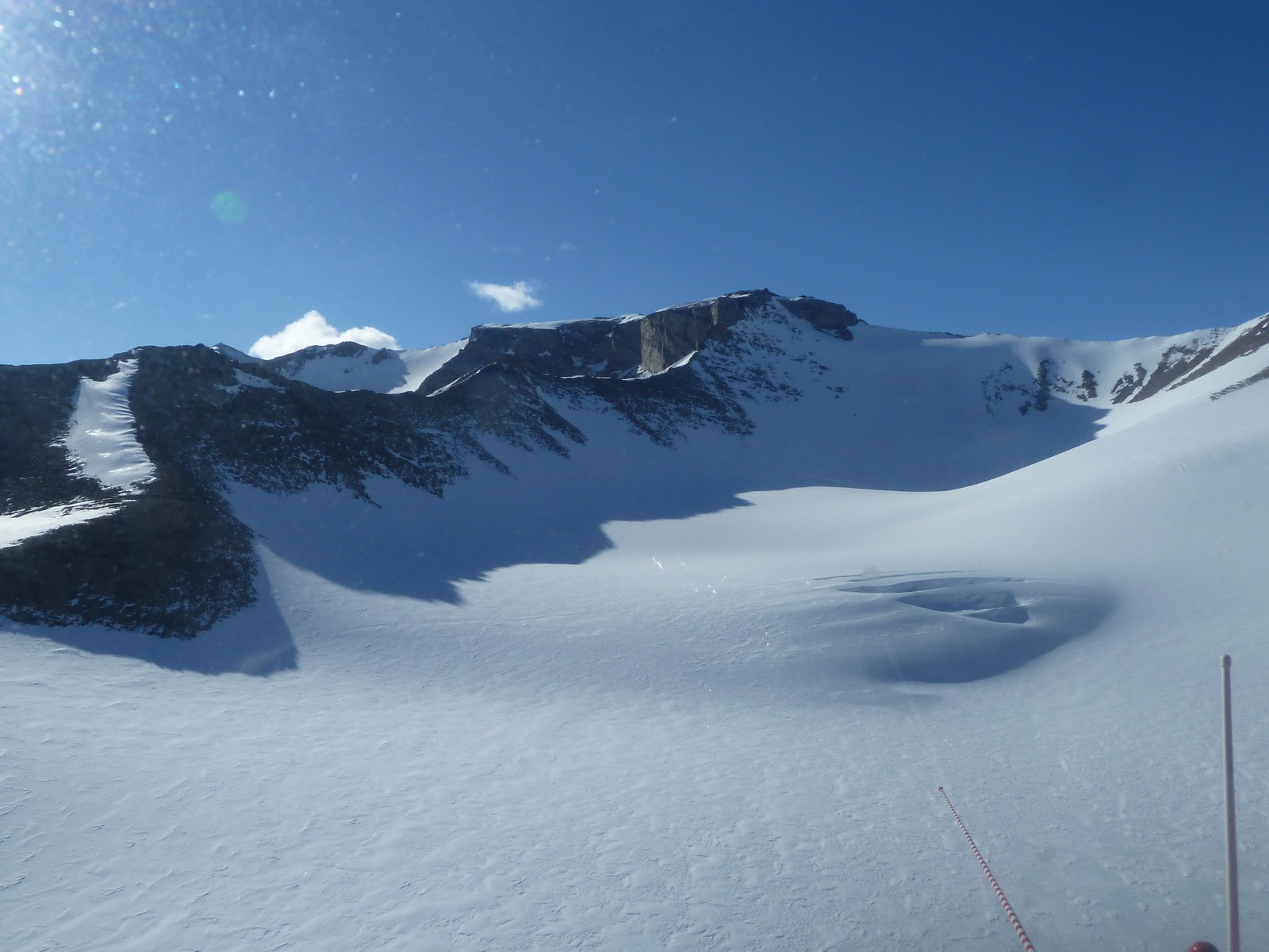
Looking up valley at Garwood glacier.
The white on the ground in the bottom left corner is salt.


The four of us hiked around the undulating and gravelly valley floor for a few hours and collected half a dozen sets of water samples. Much of Garwood Valley is underlain by ice, which is thought to be from the last ice age. The buried ice melts and forms the hilly topography. Melt water collects at low points and form ponds of varying sizes. These ponds are often riddled with life!

One of the smaller, ice-free ponds with lots of orange algae!

Some of the ponds are mostly covered in ice, like the one below. Many also have steep slopes along one side where we were able to dig into the ground and uncover the buried ice. Berry and Joe chipped away at some ice next to a large pond so that we could collect some for sampling. With these samples, we hope to determine how the buried ice chemically evolves into the pond water and how the pond water affects the Garwood Stream water.

Berry and Joe sampling the buried ice next to one of the first ponds we
sampled, which was ice-covered
 

Exposed buried ice next to the last pond we sampled. No one sampled this
buried ice for fear of it  breaking off and falling into the pond!
(Note the gap between the pond surface and the buried ice and
the icicles!)

Miers Valley

Berry, Kathy, and I flew to Miers Valley on January 16th for another day trip. Miers Valley has two glaciers, Miers and Adams, that each have streams that flow down valley into Miers Lake. Miers Lake is unique among the lakes of the Dry Valleys because it has an outlet stream. The outlet stream, which I think is also called Miers Stream, flows from the lake to the ocean. This is the only valley in this area that has this kind of “flow-through” hydrologic lake system.

Looking up valley at Adams Glacier (left) and  Miers Glacier (right). The stream
in this shot is from Adams Glacier

I saw my first “mummified” animal in Miers Valley. As Berry, Kathy, and I walked toward Miers Glacier to collect a sample of Miers Stream, we came across a dried seal carcass. Seals and penguins trek into the Dry Valleys, probably because they are mentally impaired from illness or a preexisting mental issue, and eventually die. Their bodies do not rot, but they do dry out and disintegrate with time. These carcasses are quite shocking to come across in this barren landscape and impress upon me the harsh conditions we have the visiting. I should also note here that when we get dropped off by helicopter into a valley like this that has no field camps in it and left alone for several hours we have survival bags dropped off with us that contain gear for food and shelter. With three people on this excursion, we were left with two survival bags (one bag has the gear to keep two people fed and sheltered for two days).   

Seal remains and Miers Glacier as we walked to Miers Stream

The most action-packed part of this trip was at the end after collecting several stream samples in the valley upstream from the lake. After the helicopter picked us up, we popped across to where the stream flows out of the lake, landed, and I got out of the helicopter (with the engines still running!) to collect water samples from the stream. We did this again mid way between the lake and the ocean and a third time near the mouth of the stream where it flows into the Ross Sea. This was the most exciting water sampling (or even field work) that I’d ever done! Unfortunately I don’t have any photos of this because I was collecting samples by myself and didn’t have time to snap a self portrait, but Berry may’ve taken a snapshot or two of me from the helicopter.

Looking toward Ross Sea across Miers Stream and Miers Lake. My
speed sampling was off in that direction past the lake but before the sea!

Tuesday, January 10, 2012

(Not so) Short catch-up post (first field work, New Year's, Limno Team Lightening Round, Marr Ponds)

8:15pm Tuesday, 1/10/2012
35°F


I am waaaaaaaay behind in posting. A lot has happened in the last two weeks! 


I my first field work with my co-worker Kathy from December 27-28. We did a 2 day overnight trip to Talyor Valley and collected samples along Priscu Stream on the first day, stayed the night at Lake Hoare field camp, and then sampled Delta Stream the next day. On the way back to McMurdo from Delta Stream, took the long way around/across Taylor Glacier and made a short stop in Miers Valley to collect 2 samples. Priscu Stream starts at the La Croix Glacier and flows west and ends at East Lake Bonney. Delta Stream flows north from the Howard Glacier and ends in Lake Fryxell.

Kathy getting across Priscu Stream with the La Croix
Glacier behind her

My Scott tent and me in front of the Canada Glacier at
Lake Hoare field camp (you can see a bit of the lake
to the right of me in the photo)

Howard Glacier at the head of Delta Stream


Life in Delta Stream!


Me in the helicopter as we flew over
Taylor Glacier


The helicopter (a Bell 212) we took from Delta Stream,
over Taylor Glacier, to Miers Valley
(this is in Miers Valley)


New Year's Eve was a fun celebration with a chili cook off and an outside concert. It really amazes me how talented a lot of the people here are. I spent a good chunk of time before and during New Year's Eve cleaning/preparing sample bottles for use in the field once my PhD adviser got down here.


Oh! I did a "night" hike to Castle Rock, which is ~2 miles north of McMurdo, the night before New Year's Eve. A big group of us went out at about 8pm and hiked over to the rock and climbed up it. 


Castle Rock and me at 11pm on 12/30/2011
Poorly framed photo of me with
Mt. Erebus in the background taken
from the top of Castle Rock


Berry arrived on the 3rd. Right after he arrived I departed for a 4 day trip to Taylor Valley with the Limno Team (team in our research group that studies lakes, aka limnology) to help with their "Lightening Round" of sampling. The Limno Team focuses on the four lakes in the Taylor Valley: Fryxell, Hoare, East Bonney, and West Bonney. Their "Lightening Round" of sampling included depth profiles with several instruments that measure light intensity, chlorophyll, salinity, and other geochemical parameters, and collecting 11-16 samples through18-38 meters of the water column, depending on the lake. The water we collected at predetermined sampling depths was later partitioned for various uses, like bacteria samples, dissolved organic carbon, nutrients, anions, cations, and chlorophyll (collected on filters). I also collected my own samples directly from the water we took from depth (using a Niskin sampler- http://en.wikipedia.org/wiki/File:Niskin-bottle.jpg). I will analyze the stable isotope composition of the lake water itself to determine whether/how much evaporation has affected the lake water. I didn't take photos during the "Lightening Round" because we were so busy! But, I did take a few  photos after we sampled at Lake Hoare field camp because we had a weather day and could not be helicoptered (I guess that is a verb) to Lake Bonney. East and West Lake Bonney are connected by a shallow river. That area is called The Narrows. The lakes are considered separate, however, because the chemistry of each lake is different. 


Lake Hoare Field Station

Looking west from Lake Hoare
camp down Taylor Valley
Looking south (ish) from Lake
Hoare camp across the lake and
at Canada Glacier
Looking east from Lake Hoare 
camp at Canada Glacier and
 the labs and solar panels

After getting back from "Lightening Round" we had lots of sample processing to do, well all I had to do was filter a lot of samples. But, I helped my fellow Limno Team with their samples. We had to filter samples and prepare samples after sampling each lake. This was quite a lot of work to be sampling all day and then all afternoon and evening processing samples. It was great fun!


A couple days after getting back, Berry, my PhD adviser, and I went for a day trip and sampled the Marr Ponds, which are just north of the toe of the Marr Glacier along the southern wall of Talyor Valley. We did this work today, in fact! Hooray, I am caught up!! We only had a couple hours of ground time. After scoping out the area we collected a few samples (one set from each pond) and then headed back. Today was only the second time that I've gotten to fly in an A Star. They are the sports cars of the helicopters down here, of which there are only two types with the other being a Bell 212. A Stars don't require a technician besides the pilot and one of the passengers gets to sit up front next to the pilot and enjoy great views!


From left to right, the A Star, me, and Berry in the Marr Ponds area