4:50pm Friday, 1/20/2012
27°F
I decided that I should preface this post, albeit belated, with a short discussion of where I actually am. I am based out of McMurdo Station, which is located on an island (Ross Island) in the Ross Sea. Ross Island hosts several cinder cones and the active stratovolcano, Mt. Erebus. At this latitude, Ross Sea is ice covered for much of the year and the ice-covered sea is dubbed the Ross Ice Shelf.
 |
| Map of Antarctica, with the red square roughly outlining the areas I have visited |
The Dry Valleys are located on the main continent of Antarctica and are due west of Ross Island. There are several valleys in this area and I have had the privilege of visiting four of them: Taylor, Miers, Garwood, and Wright.
 |
| The locations (I think, the text is pretty blurry) of the four Dry Valleys I've set foot in so far relative to Ross Island 1- Wright Valley 2- Taylor Valley 3- Garwood Valley 4- Miers Valley |
 |
| Another map of the Dry Valleys, with the four valleys I've visited highlighted |
Wright Valley
Amy (of the Limno Team), Micheal Davis (who works in the lab facility in McMurdo where my group has a few rooms), and I flew to Wright Valley on January 17th for a day trip to sample the Onyx River. This was my first “solo” field excursion in Antarctica, meaning I was in charge of this sampling work! I was tasked with collecting eight sets of water samples along the extent of the Onyx River at coordinates that have been sampled in previous years. The Onyx River is the longest river in Antarctica. It is 25 miles long and flows from Lake Brownworth to Lake Vanda; the Onyx River is unique in that it flows away from the ocean (east to west in the maps above).
Amy, Michael, and I were on time and well prepared for our trip to Wright Valley. We arrived at the helicopter hanger well before our scheduled 8:15am departure time. The helicopter technicians were so proud of us that they took our photo in the hanger.
 |
| Michael, Amy, and me. Of course, my eyes are shut... |
We had the pleasure of flying in an A Star because we had closed support, which means the helicopter would stay with us as we did our work. The flight out to Wright Valley was beautiful. Clouds at the seaward end of the valley forced us to fly over the peaks along the south wall of Wright Valley, which make up the Asgard Range. There is a ridge line that is very wind eroded. It was beautiful!
 |
| Flying across Ross Sound to the Dry Valleys. Not sure which valley that is... |
 |
| The eastern/seaward end of Wright Valley socked in |
 |
| Wind eroded ridge on the southern wall of Wright Valley |
 |
| Looking at the eastern/seaward end of Wright Valley socked in from in the valley |
Sampling the Onyx River was incredibly exciting. My two assistants were very helpful. Amy measured pH (acidity) and temperature in-situ (i.e. directly in the river water) with a handheld instrument, Michael wrote down the pH and temperature values, and I collected water samples for major ion chemistry, dissolved organic carbon, total nitrogen, and the stable isotope composition of the water molecules themselves.
 |
| Amy (left) measuring ph & water temperature and me (right) collecting water samples |
We were able to collect four of the eight samples before we had to fly back to the coast of McMurdo Sound, to Marble Point, to refuel. The flight out of the valley was spectacular and then it was gloomy at and around Marble Point.
 |
| Flying over a glacier on the southern peaks along the Wright Valley on the way to Marble Point to refuel |
 |
| Getting very close to Marble Point, the white in the background to the right is Ross Sound |
The flight back to Wright Valley from Marble Point was also spectacular! We took a slightly different route over some beautiful ice falls. Amy said this trip, in its totality, was one of the most amazing and spectacular of her time in Antarctica. Michael had never been out to the Dry Valleys before. He works in what we call "Science Cargo," so it was wonderful that he was chosen as our extra helper on this trip.
 |
| Looking south from above a glacier in the Asgard Range |
 |
| Michael (left) and Barry (right; the pilot!) as we flew back to Wright Valley for the last 4 samples |
 |
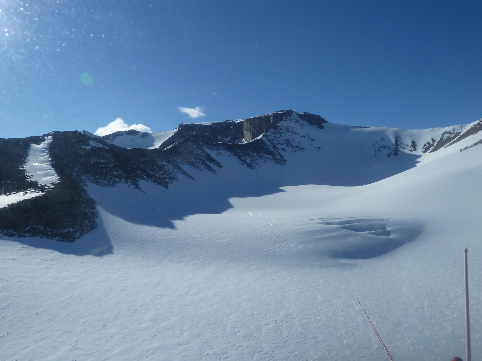
| Close up of some ice falls in the Asgard Range |
 |
| More of the ice falls in the Asgard Range |
 |
| Looking upstream toward the sea in Wright Valley along the Onyx River, there was still cloud cover near the sea |
 |
| Looking downstream in Wright Valley along the Onyx River |
We collected the latter four sample sets along the Onyx River with as much ease and speed as the first four. The water was very cold, just above freezing, and the river was lines with ice along its banks at most sites. The final sampling site, which is just before the river ends in Lake Vanda, was spectacular. Lake Vanda is a beautiful shade of turquoise and just before it empties into the lake, the river runs over larger rocks than in the rest of the valley making lots of noise.
 |
| The bank of the river channel was more than a foot high and saturated with water at the second to last sampling site so I lay on my stomach to collect the water samples |
 |
| Looking upstream from the last sampling site right next to Lake Vanda. Look at all that water! |
 |
| Michael and Amy at the last sampling site |
 |
| Me at the last sampling site in front of Lake Vanda and the end of the Onyx River |
Our flight from Wright Valley to Taylor Valley, which was where Amy and I were spending the night, was, as you might guess, absolutely spectacular. Instead of oodles more photos, I would love to post a 90 second video of our helicopter ride as we passed into Taylor Valley. But, it seems I can't. I shall end this post with these three photos of our flight from Wright Valley to Taylor Valley. Since this post is so long, I shall post again about our stay at Lake Hoare and our adventure hiking around on the lake in life vests. Hopefully I can figure out how to post videos, if it's possible to do from down here...
 |
| Looking back toward Wright Valley across a high elevation glacier valley in the Asgard Range |
 |
| Looking toward Taylor Valley in the Asgard Range |
 |
| Looking down Taylor Valley toward the sea. The glacier in the foreground is the Seuss Glacier, which forms a barrier between Lake Hoare and East Lake Bonney. The next is the Canada Glacier and the glacier furthest in the background, past the lake (Fryzell) beyond the Canada Glacier, is the Commonwealth. |
Where is the onyx river on a map?
ReplyDelete